This is the year that I finally got a chance to hike across the Grand Canyon! We've applied for a permit before and not received it, this year I got one leaving from the North Rim hiking to the South Rim, via Cottonwood, Bright Angel and Indian Gardens campgrounds in the canyon. After seeing the size of the Cottonwood campground, that probably is the limiting factor in previous requests since it is a fairly small campground. However, Cottonwood is halfway between the start of the North Kaibab trail and the river (7.5 miles in) so is also a useful place to stop. This trip was with the boy scout troop, so Kyle accompanied me along with another adult leader and 3 other scouts.
We drove up to the North Rim on Saturday and started hiking about 1PM. The drive from Mesa takes about 6 hours, we had another adult along who took the vehicle around to the South Rim, another 4+ hour drive. Another reason to stop at Cottonwood, starting earlier is hard to do if we're driving up that day. The trip was planned over the Mesa schools fall break, and temperatures on the North Rim drop below freezing at night in October - so sleeping on the rim isn't something we're interested in. The permit also started on the Saturday of fall break, so getting up to the rim on Friday would be difficult. From the trailhead to Cottonwood is 7.5 miles with ~4000 feet of elevation
drop, then another 7 miles to the river, with another 1800 feet of elevation drop.
 |
| Day 1 Elevation profile |
We had some rain during the day, but fairly light such that most people didn't put on rain gear. The hike down was a lot of work - especially with a pack. My legs were sore after about 3 miles, and stayed sore for the rest of the trip, especially going downhill. Climbing wasn't as much of a problem, just descending....
 |
| Fall colors in the canyon |
 |
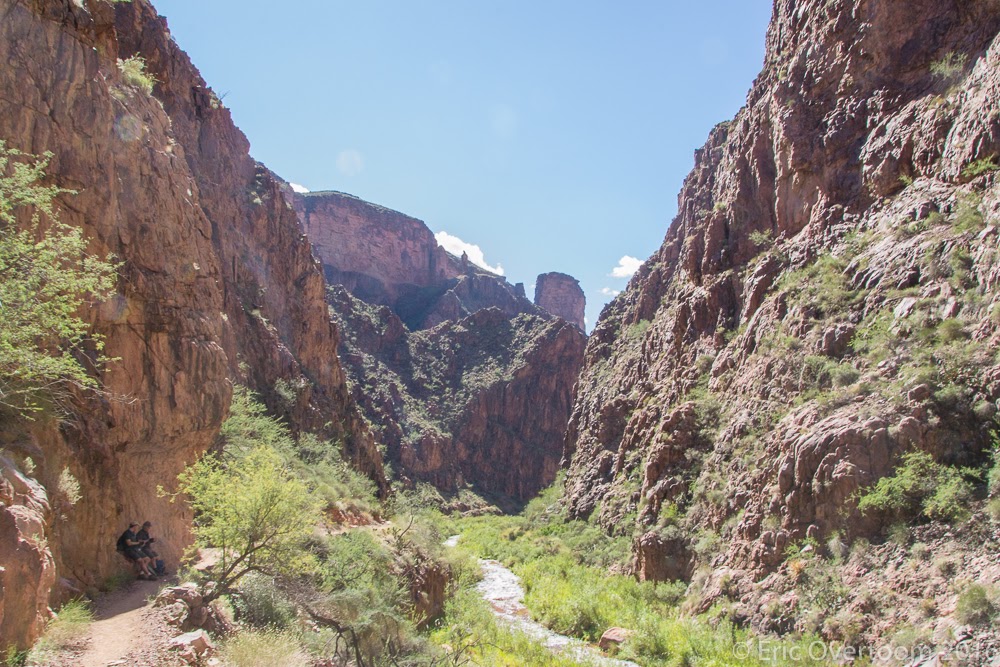
| Looking along the North Kaibab trail |
 |
| Interesting streaks in the rocks |
 |
| A view of Roaring Springs - the canyon water source |
We got into the campsite around 5PM, just before sunset, with enough time to setup tents. Being one of the last groups into Cottonwood meant that many of the good sites were taken, we had to move around the picnic table to make enough room for all of the tents - though there wasn't much free space after the tents were up - requiring some care in moving around...
Day 2
The second day was to the Bright Angel campground, near the Colorado River at the bottom of the canyon. This was
mostly descending, with a few little climbs. We took a side trail to see Ribbon Falls, a stream cascading down into the canyon. This day also hiked through 'The Box', a narrow canyon with high walls, barely wider than Bright Angel creek (which the trail was following from Roaring Springs). The adults arrived at Phantom Ranch around noon, got some cold Lemonade, then continued the quarter mile further to the campground, where the 3 faster scouts had already setup camp. After lunch, those who were interested hiked to the river and across the black suspension bridge, seeing the indian ruins along the river.
 |
| Cottonwood to Bright Angel elevation profile |
(Note that because of the high canyon walls, GPS tracking was inaccurate, so the big bump shown from miles 7 to 8.5 wasn't really a climb...)
 |
| Morning in Cottonwood |
 |
| Ribbon Falls |
 |
| Side stream along Ribbon Falls |
 |
| Kyle behind the top of Ribbon Falls |
 |
| Bottom of the falls |
 |
| Into the box canyon |
 |
| Ruins along the river |
 |
| The Black suspension bridge |
Day 3
After two days of descending, it was time to start working our way out of the canyon - as many signs point out, descending is optional, climbing out is not. We had planned to do the 8 miles of the Bright Angel trail over two days. Climbing out on the South Rim gains about 1000 feet less than the North Rim, so that also factored into the route - less climbing. We easily could have done the climb in one day - even the adults reached Indian Gardens by 11AM, but we would have then faced a drive home and arrived back to Mesa later than we'd like. The Bright Angel trail starts along the river, then climbs, gaining about 1800 feet over 4.5 miles.
 |
| Elevation gain Bright Angel to Indian Gardens |
 |
| Looking back towards the river on the Bright Angel |
The afternoon was spent in camp, in the shade, with an evening hike out to Plateau Point to see the sunset. Unfortunately, clouds obscured the actual sunset, and prevented us from seeing the reds and oranges in the canyon being picked up by the light of the setting sun.
 |
| View from Plateau POint |
 |
| Near sunset - light coming under the clouds |
Day 4
The final day was climbing up to the South Rim, picking up about 3000 feet in 4.5 miles. The hike was a lot of switchbacks, with great views behind us. The interesting part was that the hike was mostly in the shade, with the temperature staying constant as we climbed up.
We reached the trailhead around noon, after some short stops at the 3 miles and 1.5 mile resthouses to breakup the climb.
After lunch, time to drive back to Mesa, we arrived back around 5PM.
Throughout the trip, I just used my tarp over the sleeping bag. I used my new Nemo Salsa 15 bag, even though the temperature never got below 50 on the hike - this bag packs down much smaller than my other and that drove the decision more than the need for temperature. I didn't expect trees, so didn't bring the hammock (and would have only had a chance to hang at Indian Gardens). The pack ended up being heavier than I really expected, so I'll have to sort out where all the weight came from (some was food, but...). This was a great trip - along the corridor the views are always changing, and throughout the day the changing light made for ever changing aspects to the canyon. I'd like to go again and maybe descend the South Kaibab trial - partly to see the views from that trail, and so that I can claim the canyon portion of the Arizona Trail (descending South Kaibab and ascending North Kaibab). Based on what I saw of the campgrounds, just requesting Bright Angel campground should be easier to get a permit for than including Cottonwood.