Sunday, March 20, 2016

Reavis Ranch Backpacking Trip March 2016

Kyle and I went with a few (3 others, to be exact) scouts from his Boy Scout Troop on a 3 day backpacking trip in the Superstition Wilderness, about 30 miles away from home.  That's 30 miles as a bird flies, 52 miles and 2 hours of driving...  This was at the beginning of Spring break for the schools here, and met the requirements for the first of 3 hikes for the backpacking merit badge (each hike > 13 miles, 3 days and 2 campsites).  We had done some prep hikes, including hiking with packs to make sure that things were adjusted properly and so we'd be used to the pack when we started hiking.  The particular destination was the Reavis Ranch area, a meadow where Elisha Reavis had a farm and apple orchard in the 1880's.  There is a creek running through the meadow, so water would not be a problem.  This is a fairly popular destination, and we saw at least 4 other groups in the meadow the night we camped there.

The route:


The plan was to follow trail 109 (Reavis Valley Trail) to the ranch site and camp.  This involved descending 400 feet, then climbing 800 feet across Reavis Saddle, then gradually descending 400 feet again to the ranch site (leaving us at about the same elevation as the trailhead - 4800').  Day two would be a trip to a Sin Agua ruin called Circlestone, at the top of a 6000' hill next to Mound Mountain, then camp near the saddle.  Day three was a return to the trailhead and civilization.

Temperatures were forecast to be a little cool, but not too bad - with adjustments for elevation (High/Low):
Sat 66/40
Sun 74/44
Mon 78/46

Day 1 - March 12
We started from the church the troop meets at, and drove to the Rogers Trough Trailhead.  This involved ~15 miles of dirt-road in increasingly poor condition, including the last mile marked by the forest service as 'High clearance required, 4WD strongly recommended'.  Only one spot this time that was loose enough to need 4WD, but if the road was wet at all there would be more places that would be hard to climb without it.  High clearance was definitely needed in several places.
Rogers Trough Trailhead
We started the hike about 9 AM, dropping down into Rogers Canyon and then heading up Reavis Canyon towards the saddle.  We reached the top of the saddle about 11:45 and stopped there for lunch, and some map-and-compass exercises for the scouts.  The climb up the saddle was through mostly small mesquite trees and manzanita - all low shrubs.  It is amazing how green everything looked - this area had seen rain during the previous week, and it showed in the green of the shrubs and trees, and some areas of standing and flowing water in the creek beds.  Looking out from the saddle, the green hills could easily pass as another part of the country that isn't as dry as Arizona, just green rolling hills (since there weren't any saguaro cactus in this area).
Rogers Canyon 
White Mountain
Reavis Canyon from Reavis Saddle
Hills by the saddle
We had an easy and casual descent the 3+ miles to the ranch site.  On the north side of the saddle we quickly dropped into a Ponderosa Pine forest, so it felt much more like hiking along the Mogollon Rim in northern Arizona.  We saw a few other groups, some day-hikers and some other backpackers.  At the meadow we could see the floor of the ranch house - the rest burned down about 20 years ago, and looking at a nearby fire ring much of the stone from the house was used there...  We occupied a nice campsite with a fire ring near the creek, setup camp and the scouts collected firewood, waiting until dark to actually light the fire.  I found 2 trees that I could setup my hammock between and got situated, with a tarp over the hammock to help keep any wind off me.  I use an air-pad under me in the hammock as insulation, and had a liner in the sleeping bag to offer a little extra insulation - which would be much appreciated by the morning.  After the sun went down it cooled off quickly - we were at about 4800' in elevation, so it was expected to be cooler than in Phoenix, but we could see breath by about 8PM, so most everybody was in their tent shortly after that.  I was OK until about 10:30, then started getting cold, so I put on another layer of clothes - I went to sleep with a long-sleeve heavyweight shirt and running tights on, I added a down vest and my pants over that, and cinched up the sleeping bag.  That held until about midnight, when the cold seeping in through my sides (where the hammock was pressing in) got to be too much and I just dropped down to the ground where nothing would be compressing the sides of my sleeping bag.  That got me through til dawn, but it was still a pretty chilly night, with cold feet.

Total hiking - 7.5 miles

Reavis Creek
Remains of Reavis Ranch house


Day 2 - March 13
For the last part of the night, sleeping on my left side was good, on my back was a little chilly and on my right side presented a really cold breeze right into what of my face was exposed.  I held out in the sleeping bag until I could finally see sunlight on the hill near us, then jumped out, put on my windshell and boots and started working to warm up.  I was a bit surprised to see (a) that my water bottle was mostly frozen and (b) my thermometer shows a temperature around 26 degrees.  I had not expected below-freezing temps, and was glad for the liner in my sleeping bag.  I was using my 30 degree bag, and the liner claims to add 10 degrees to the comfort level - something I was glad for, since I was only uncomfortable and not worse.  All of the scouts and leaders made it through OK, though everybody was cold during the night.  One nice thing about packet meals is that once you add hot water, tucking the pouch inside a jacket is a nice way to warm up a little.  The scouts also found goofing off in the sunlight to be helpful.  We didn't get camp broken until 11AM, a bit later than we'd hoped, but it was a lot colder than we hoped also.


We had camped 1/4 mile from the trail towards Circlestone, so we hiked to that intersection and stashed the packs off the trail, bringing just lunch and water along on the 3 miles to the ruins.  The hike along the Fireline trail was nice, never climbing too steeply, with some nice views of the mountains.  At the top, the ruins were, indeed ruins, with a really nice view of several valleys and ridges, and a great view of 4Peaks to the north.  We could even see another set of ruins in Rogers Canyon (near Angel Basin).  We descended, returned to the packs, filtered water at the creek, and we hiked the 3 miles to a campsite about 1/2 mile below the saddle.  This was a little tighter, but was the last easy place to camp and get water before the saddle, and we didn't really want to camp exposed to the wind as we would be on the saddle.  For this campsite there weren't great trees to hang from, and I wanted better protection from the wind anyway, so rigged up the tarp as a shelter and slept on the ground.  This night was much warmer, with no wind that bothered me, so everybody was much more comfortable.  Morning low was 40 degrees, so whatever little cold spot we were in the first night had passed by.  There was some moderate wind during the night, heard in the tree tops, but barely noticed down at our level.

Hiking on day 2 - 9.1 miles

Four Peaks from Circlestone
Circlestone


Mound Mountain


Day 3 - Monday March 14
Woke up to 40 degrees, everybody broke camp more quickly and we were on our way up the saddle by 9:30.  Climbing back up from Rogers Canyon to the trailhead was slower and harder than some of the scouts may have thought, so we got to the trailhead again about noon, and had lunch before starting back to town.

Day 3 hiking : 4.0 miles
Total : 20.6 miles over three days
Reavis Canyon on the descent from the Saddle

Looking back on the road to Rogers Trough TH
My gear worked out pretty well - aside from the issue with the temperature and the hammock.  I'll have to check into an underquilt if I plan to hang in cold temperatures again, and I've already been planning a new sleeping bag with a lower temperature rating.

My gear:
backpack - Osprey Atmos 50AG - no problems with the pack, the suspension is great and it felt a lot lighter than the 39+ pounds that it weighed with all my gear.  Everything I needed fit into the pack - though I would have been hard pressed to get much more if I needed to.
Sleeping Bag - Sierra Designs 30 degree + Thermolite liner.  This really isn't a backpacking bag, and it occupied more than 1/3 of my pack volume - definitely something to change for a longer duration trip.
Sleeping Pad - Klymit Inertia O-Zone - lightweight backpacking air pad, with cutouts in a variety of places to reduce weight and avoid compressing the sleeping bag insulation.  Worked well on the ground, no so well in the hammock.  I was plenty warm on the ground, even if it looks like its full of holes.  Packs down to a pop-can sized cylinder.
Hammock - Eagle Nest Outfitters Double Nest + Atlas straps.  I used a Hex-a-tarp over the hammock for this trip, will prefer a longer and wider tarp next time to better keep out of the wind.  I used the footprint from my backpacking tent (that Kyle used) as a ground cloth when I slept on the ground.
Water filter  - Katadyn Hiker.  A little heavy, but the people who brought pumps found them much appreciated.  One leader had a Sawyer mini, and found that dipping into an almost-freezing creek to fill a pouch was less than comfortable...
Stove - MSR Whisperlite Universal - I appreciated this stove, since others were finding on the cold morning that the butane gas stoves (Jetboil, MSR Pocket Rocket) weren't working as well due to the temperature.  With the Whisperlite I could turn the butane cylinder over and burn liquid butane which worked much better for boiling water.
GPS - Garmin Etrex 20 - one set of batteries made it through all three days.  I had pre-loaded the routes (from HikeArizona.com), so we knew we were following the right trails (especially Circlestone which isn't all on maintained trails).
Map - National Geographic Trails Illustrated "Superstition & Four Peaks Wilderness Areas" #851

Meals - Kyle and I ate home-made and dehydrated meals, which really worked out well and were a lot cheaper.  A combination of things that we made specifically to be dried, and leftovers that we dried out.
Lunches were always sausage, cheese and Wasa (most of my food weight and volume...)
Sat dinner - Vegetarian chili
Sunday bkfst - oatmeal (regular oatmeal, premixed with brown suger, cocoa and raisins)
Sunday dinner - Shrimp Etoufee - from the book 'Scouts Best Backpacking Meals'
Monday bkfst - dried scrambled eggs - the only let down.  I dried these myself, and they really didn't re-hydrate after 30 minutes, they were still a bit rubbery.  Might just need more time, might need to rehydrate overnight...
Snacks - home dried apple chips, Clif bars, nuts

This was a good trip - got me excited to go out and do some more trips in the Supers.  Lots of trails, and lots of 2 day loops that can be done on a weekend.

Monday, July 6, 2015

Independence day at West Clear Creek

For Independence day we sought to get out of the Phoenix Metro area, and the heat, and go where it would be a little cooler and we could enjoy walking in the forest (a real forest, not a cactus forest...).  We drove 2 hours up to Camp Verde, and to the West Clear Creek wilderness area.  There is a trail that follows Clear Creek for a ways, and the creek itself, with pools and plenty of places to jump in and get wet.  Camp Verde is only about 10 degrees cooler than Phoenix, so splashing in the water would be welcome.

The trailhead is in the Bull Pen day-use area, at the end of Bull Pen Road.  The trail goes past the namesake for the area, the former Bull Pen Ranch.  Bull Pen Road is drivable by regular cars (we saw sedans and minivans in the parking lot) but I was glad we had a high-clearance vehicle, there were a few deep ruts and large rocks that would really rip up a smaller car.
Have fun!
Within view of the parking area was a cliff face that really looked like a face - broad smiling mouth, wide-set eyes.  Almost like it was talking to us.  The first mile or so of the trail goes through a meadow, and past the old ranch house, before dropping to the creek.  There is creek access closer to the parking lot, which was full of people up picnicking and splashing - a little louder than I would prefer.  Walking across the meadow was a little hot in the sun, but with good views of the surrounding cliffs.  The meadow climbed up a little bit, leaving the creek in a canyon - it wouldn't be easy to work up along the creek for very far.
Bull Pen Ranch
First view of the creek - upstream
Once we got to the creek it was shady and much cooler.  The trail went along the north side of the creek for a while, on a narrow bit of land and rock, with rock stairs in a few places, before coming to the first stream crossing.
Looking downstream


We crossed the stream at two places - the first was a little deeper, past my knees, the second was shallower than that.  Between the two crossing we moved from the day-use area into the wilderness.  The Clear Creek Wilderness extends the whole length of the creek in the Coconino National Forest, the trail goes for 8 miles before climbing out of the canyon.  Past the end of the trail (another 20 miles or so) is harder navigation, with some places requiring swimming in the creek between steep canyon walls.  We only went about half a mile past the second crossing, before deciding that the sky didn't look favorable for continuing the trek (unless we wanted to possibly extend our stay in the creek longer than I would prefer...)  
 We could see darker clouds gathering around, as we returned to the first stream crossing, which had a number of large rocks to sit on while we ate our lunch.  The kids went out into the creek and splashed a bit - walking in the water was really nice and cool.  We played until we started hearing thunder.  Not wanting to get caught on the wrong side of the creek if the water started to rise, we crossed and started back towards the parking lot.


We walked about 10 minutes before it started to rain a little, then another 2-3 minutes before the skies opened up and we broke out the raincoats and ponchos (at least those who brought them...).  The rain continued until we got back to the car, by which time it was starting to slow down.  The parking lot didn't get as much rain as the canyon did.  I was quite wet by the time we reached the car.


All in all - a really nice trail and a nice canyon.  Once we got a little ways along the creek on the trail we didn't see any other people, the people up to splash for the day stayed within about a mile of the parking lot.  The rain wasn't a huge problem, it was still pretty warm (in the 80s) so once the rain stopped it wasn't too uncomfortable.

A few lessons learned:
  • Waterproof hiking shoes are not the best to wear on a trail with stream crossings.  Reading about the trail it sounded like it was possible to manage the first few crossings without getting in too deep, but the water might have been a little higher.  I didn't really get all the water out of my shoes until I took them off, and even then they were damp 2 days later.
  • I didn't prepare for the weather like I wish I had.  I packed more for lazing in the shade than for a thunderstorm.  If we had been caught across the creek and the water rose substantially we might have been there a little while, and we didn't really have supplies for that.  Having at least a tarp would have been good, along with a few more emergency food supplies and fire-making supplies.
  • Cool water feels awesome on a hot summer day.
A few more pictures from the trail.  The creek cuts through the red sandstone that makes Sedona so beautiful, so we had pretty red walls to look at through the trees in the creek bed.


Friday, June 26, 2015

R-C Cub Adventure Camp Hammock Camping

Last weekend (Father's Day Weekend) was the annual Pack 653 trip to Cub Adventure camp, the overnight cub scout camp for the Grand Canyon Council.  This was John's last year as a camper, he will be crossing over to Boy Scouts in the spring.  This was Kyle's second year on staff as a Den Chief, helping out the campers in getting around and helping the program staff with activities.   Next year maybe John will join as a Den Chief, and it will be Kyle's last year as a Den Chief before he can be "unpaid staff" at the camp (we have to pay for Kyle to be a Den Chief, and pay for an adult to go along and help out also, so unpaid staff will be an improvement money-wise...).

I did take a lot of pictures, of scouts doing activities, some are posted below.  This year our unit had 2 scouts along without parents, so we setup a tent with just 4 scouts in it (since boys can only share a tent with their own parents).  John joined in that tent, so I didn't have to share with anybody - which made a great opportunity to try out my new hammock.  I picked up an Eagle's Nest Outfitters DoubleNest Hammock for $16 at the REI Garage Sale.  The damage tag said there was a small rip in the hammock, but I couldn't see anything but a snag in one spot.  I wanted to try out the hammock for backpacking, since the hammock parts are easier to pack (and pack around) than a tent - this was a great opportunity since I didn't need to setup a tent for John and myself.  The weather was clear all weekend, with highs in the low 90s and lows around 50.  I had the hammock along for free time napping, with John in another tent I could use it to sleep in.

Sleeping in the hammock worked well after I figured out a few things.  I did bring my sleeping pad in and slept on that in the hammock - quite important since colder air circulating under me caused my back to get cold when I slipped off the pad (and I slipped off the pad a few times the first night.  For the second and third nights I adjusted the tension on the hammock, bringing in more of a sag, and that worked well to help keep me centered and on the pad.  50 degrees did feel pretty chilly in the middle of the night - but the sleeping bad kept me plenty warm as long as I stayed on the sleeping pad.  Since the weather was going to be clear, I didn't setup a tarp over the hammock - which meant that I was up with the sun rise around 5:30 - but I will also say that I had a fantastic view of the stars in the night, through the trees.

The only real fun was on day 3 when I got back to camp to find a stream of ants walking down the suspension lines and through the sleeping bag and everything in the hammock.  They seemed to have taken offense to my setup on one of the trees, so I moved to another pair of trees and shook them out of everything...  I will probably invest in a bug net - there isn't a great need here in Arizona (I didn't notice any bugs at all) other than to catch the little twigs and needles falling off the trees.

The hammock won't work on all trips - winter trips in the desert don't often have suitable trees for hanging from - but I was able to see that it works out.  I didn't have any trouble sleeping, and didn't wake up with any stiff or sore joints like I often do sleeping on the ground.

Christopher Cree runs through the scout camp

John ready for Archery

John on a horse!

Feed Me!!!

Cow skull or tree?

Black River fishing May 2015

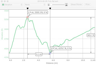
Over Memorial day the boys and I joined Troop 653 on the annual fishing trip to the Black River.  The site that they visit (and have visited for the last 15 or so years) is on the White Mountain Apache reservation, about a 4 hour drive from Mesa, with the last 12 miles and 1 hour of that drive being on an unpaved 'road' that would be the first road I've driven that actually requires a high clearance vehicle.  The Suburban ('El Carro Grande') handled the trip to the river just fine, though the last 3 miles involved a 1000 foot ascent and descent and speeds no higher than 5 MPH, with > 10% grade up and down.

The last 12 miles to the campsite

Elevation profile from the highway, crossing the White River then to the Black River

The White River and Black River join up to form the Salt River a little down stream of where we camped.  The main draw of the Black River is great smallmouth bass fishing - and from the number of fish that came back to camp it looks like people had a good time fishing.  I caught 2 small bluegills and one small smallmouth, John caught a small smallmouth - none worth keeping, but enough for us to get invited into the Benevolent Protective Order of the Fish Head.  On the elevation profile, the dip in the middle is the White River, the left side is the Black River and the right side is the highway.  Quite an exciting drive, with big rocks, bumps, and things that would rip parts of smaller cars off...

It was a little chilly over the weekend, especially considering that getting anywhere on the river involved walking in the river.  Highs in the 70s, lows around 40 at night.  Most of the weekend did involve fishing and cooking fish, or playing games in camp.  I don't have a lot of pictures from fishing - not wanting to bring along the big camera and risk it getting wet (something which would have happened).  In the course of fishing I slipped twice and sat down right in the river (generally less than 3 feet deep), and got plenty wet.  The mornings were beautiful, calm air, calm river and bird song to listen to.  No electronic distractions (we were quite a ways out of cell-phone range).  Some wildflowers in bloom in the meadows and along the river.  This being Arizona, even though we were high enough for trees to grow there are still a good number of cactus growing as well, and the prickly-pear were also in bloom.

Looking upriver from camp

Looking downriver from camp
 The camp site (Tick Flat) was right near a fork in the river where there was an island.  The following pictures were taken in the early morning looking down the smaller leg of the fork, where there were more rapids.  One interesting thing to note - the island rose up about 8 feet above the river, yet shows signs that it gets submerged...


Evening looking across the river

Flowers on the hill
The trip was great for being able to just relax.  We didn't have any real wildlife encounters - other than a really annoying bird that perched in the top of a tree near the camp and was calling all night long, making it a little hard to sleep.


Wednesday, May 20, 2015

Chiricahua National Monument, April 2015

We took a family trip to camp for the weekend in Chiricahua (cheer - i - caw - a) National Monument in south-eastern Arizona about 4 hours drive from home.  Chiricahua is known for rock spires and columns, caused by partial erosion of rocks in the mountains.  There are a lot of hoodoos, and other rock formations which look like people and other things (other than rock...).  It was really pretty interesting to see some of the rock formations, and some of the other things in the park.  The park is a 'sky island' - a group of mountains rising up from the plains, and providing cooler environments at altitude, with a little more water than in the lower grasslands.  So there are more trees, and some species that can't survive in the lower desert, like coatis.  We didn't see any coatis, but we did see plenty of very bold Mexican Jays.  The campground was full of jays that were willing to approach very close to us, steal food from the dogs bowl, steal food from our hands, and generally watch us like little robbers.  I don't have any good pictures of the birds, but there were quite persistent and annoying.
Hoodoos in the park
Being mid April, and some abnormally cool weather in Arizona in general, the days were great for being outside and hiking, while the nights were a little chilly, causing us to turn into the tent pretty soon after dinner.  According to the ranger station, the low temperature on Friday (our first night) was 38 degrees, Saturday was around 70 for a high and 40 for the low.  Both days warmed up very quickly once the sun was up.  The campground is at about 5400 feet elevation, the high point in the park is over 7000.

Saturday morning we took advantage of the shuttle from the campground to the upper parking lot at the Echo Canyon trailhead.  Our plan was to hike back to the campground, a distance of about 7 miles.  We hiked on the following trails back to the campground:

  • Ed Riggs trail
  • Mushroom Rock trail
  • Big Balanced Rock trail
  • Heart of Rocks loop
  • Sarah Deming trail
  • Lower Rhyolite Canyon trail
Along the way there were plenty of sights to see:
Cochise Head formation
Yogi bear checking out a pic-a-nic basket

Steve from the Bloom County comic strip
Cactus in bloom
Horsing around with rocks
Ed Riggs dropped down into a canyon, then we climbed up on the Mushroom Rock trail to join with the Big Balanced Rock trail.  Most of the hike on the Big Balanced Rock trail was in the open - the Horseshoe fire in 2011 burned most of the this area in the Monument, and much of what we saw was charred trees on this trail.  The Big Balanced Rock trail ended at its namesake rock - a 2000 ton boulder balanced on top of a column (and here sticking out of John's head).
Ouch - the weight on my head!
The Heart of Rocks Loop has a number of formations in one place that were interesting:
Kissing rocks
Rock duck on a rock
After the Heart of Rocks loop, we descended back to the campground over about 3 miles - all downhill, with views into the surrounding grasslands, some flowers, and more rocks.  And a lizard sunning on (what else) a rock.
Blending right in
Something is on my shoulders
7.7 miles hiking back to the campground, arriving back in the early afternoon after about 5 hours.  We only explored half of the trails in the Monument on this trip, and may be back to see some of the other sites in the area, like Fort Bowie and Cochise Stronghold.  After the hike, all of the kids were tired of looking at and learning about rocks, so it might be a while before we go to a park based mostly on the rock based scenery...


Wednesday, April 1, 2015

Welcome to the Trolls Woods

Why???

I'm starting a second blog to hold more of my wilderness encounters, keeping things separate from my deeper thoughts that go on the Shallow Thoughts blog.  The other blog is still there, and will see more work as time goes by, and I explore more.

Here I plan to put more of my preparations for an upcoming planned trip into the Grand Canyon this fall.  I've also been learning about all of the awesome hikes that are available within 2 hours of my home, and lots of possible backpacking opportunities as I warm up for the fall trip.  So, expect lots of pictures, and lots of posts about camping and hiking.

Since I live in the desert, please don't be disappointed when I don't have activities in the woods - our lovely National 'Forests' around here are full of cactus and smaller trees - I figure if the USA can call it a forest, I can still say I'm camping in the woods!  :)